
0 ? 'text-green' : 'text-red') + '">'; htmlElements += (tickerData[i].Pricediff > 0 ? '+' : '') + ' ' + numberformat(tickerData[i].Pricediff) + '
Interactive reads from the businessline desk
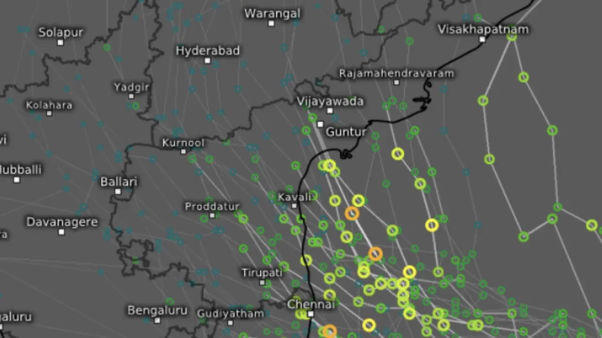
The area of influence of cyclone Akvan covered practically the entire Bay of Bengal as it struck an ominous pause off the Tamil Nadu and Andhra Pradesh coast on Tuesday evening.
Storm surge of 1.0 to 2.0 m height (3.2 to 6.5 ft) above astronomical tide may inundate low-lying areas Prakasam, Bapatla, Krishna, West Godavari, Konaseema and Kakinada districts in Andhra Pradesh during the time of landfall of very severe cyclone Akvan on Friday noon.
India Meteorological Department (IMD) said the peak surge is expected over Bapatla, Krishna and West Godavari districts from the morning till afternoon before the scenario improves gradually thereafter. However, storm surge of 0.5 m (1.6 ft) height above astronomical tide is likely to continue from early hours till evening along and off these districts.
Thunder squalls with winds howling at 60-70 km/hr and gusting to 80 km/hr may sweep Coastal Andhra Pradesh and Yanam on Wednesday and escalate further to 100-110 km/hr gusting to 120 km/hr on Thursday and Friday on both sides of the expected timeline of landfall of the cyclone, the third so far during the ongoing north-east monsoon.
Isolated very heavy rainfall is likely over Telangana on Friday and Saturday. It will be heavy to very heavy at a few places with isolated extremely heavy rainfall likely over Coastal Andhra Pradesh and Yanam on Thursday and Friday. Isolated heavy rainfall has been forecast over Tamil Nadu, Puducherry and Karaikal on Thursday; over Coastal Andhra Pradesh and Yanam on Wednesday and later on Saturday; Rayalaseema on Thursday and Friday.
Cyclone Akvan had moved slowly north-northwestwards and was practically unmoved from its location on Tuesday morning of about 610 km east of Chennai, which was closest to any coast on mainland India. This would be also 630 km to the north-east of Trincomalee (Sri Lanka); 660 km south-east of Machilipatnam; 670 km south-southeast of Visakhapatnam; and farthest at 790 km south of Gopalpur (Odisha).
The cyclone is expected to move slowly north-northwestwards and intensify as a severe cyclone over west-central Bay by Tuesday, and shift direction slightly to north-west while intensifying further into a very severe cyclone on Thursday morning.
It is likely to cross Andhra Pradesh and Yanam coasts between Nellore and Tuni, around Friday noon as a very severe cyclone with maximum sustained wind speed of 120-130 km/hr gusting to 145 km/hr.
Meanwhile, a flight from Mumbai to Kochi on Monday evening offered an unusual ringside view of a spectacular cloudscape over the Konkan-Kanara coast, raising an intriguing possibility: the expanding atmospheric circulation of Akvan may have had a hand in the display, even from well over 1,000 km away.
The observation came from the left-hand side of the aircraft at cruising altitudes of 32,000-35,000 ft, around 6 pm. Until the aircraft reached the Sindhudurg stretch of the Konkan coast, the eastern horizon was an otherwise lifeless expanse of blue and white. The cyclone was still at least 1,400 km away to the east.
Then came the transformation. The horizon suddenly lit up in glowing pink, with a broad cloud formation providing the backdrop. Above it, delicate, wispy clouds appeared to stream northwards, progressively spreading across and swallowing the blue-grey expanse. By the time the aircraft was navigating over Uttara Kannada district in Karnataka, the contrast had all but disappeared.
Could the distant Bay cyclone have been responsible? It is a plausible meteorological explanation, while not establishing a direct connection between the observed clouds and Akvan.
A cyclone is much more than the violent weather swirling around its centre. It is an expansive atmospheric engine, with towering convective clouds, powerful upper-level outflow and large-scale moisture transport. Its influence can extend well beyond the immediate storm environment as moisture and ice crystals are carried away by divergent winds at higher altitudes.
Reading the clouds from 35,000 feet over the west coast. Cyclone Akvan was raging far away over the Bay of Bengal, but its atmospheric reach may have been written across the evening sky on Monday evening (November 16). Video credit: Deepa Sebastian https://t.co/ekQ9B97CbV
One possibility is that ice crystals and moisture generated by Akvan’ s deep convection were being transported outwards by its upper-level circulation, helping to seed high-level cloud formations over distant parts of the peninsula. The aircraft may have encountered a combination of a broad cloud bank and finer, wispy formations, not necessarily belonging to the same cloud system or sharing a common origin.
The setting sun supplied the finishing touches, bathing the expansive cloud bank in brilliant orange-pink while the thinner, higher clouds appeared white or faintly pink against the blue-grey background.
There was also an optical illusion at work. As the aircraft travelled southwards, the changing viewing angle made the cloud formations appear to rise and the wisps to stream northwards, gradually closing the gap between the illuminated cloud bank and the clearer portion of the horizon.
The spectacle was a reminder that a cyclone’s atmospheric footprint need not end at its immediate neighbourhood. Its circulation, moisture pathways and upper-level winds can influence the wider cloudscape over considerable distances. Whether Akvan was directly responsible for this particular display remains an open question, but the coincidence of timing, scale and atmospheric setting makes for a compelling possibility.
Copyright© 2026, THG PUBLISHING PVT LTD. or its affiliated companies. All rights reserved.
Comments have to be in English, and in full sentences. They cannot be abusive or personal. Please abide by our community guidelines for posting your comments.
We have migrated to a new commenting platform. If you are already a registered user of TheHindu Businessline and logged in, you may continue to engage with our articles. If you do not have an account please register and login to post comments. Users can access their older comments by logging into their accounts on Vuukle.
Terms & conditions | Institutional Subscriber



Loading comments…