
0 ? 'text-green' : 'text-red') + '">'; htmlElements += (tickerData[i].Pricediff > 0 ? '+' : '') + ' ' + numberformat(tickerData[i].Pricediff) + '
Interactive reads from the businessline desk
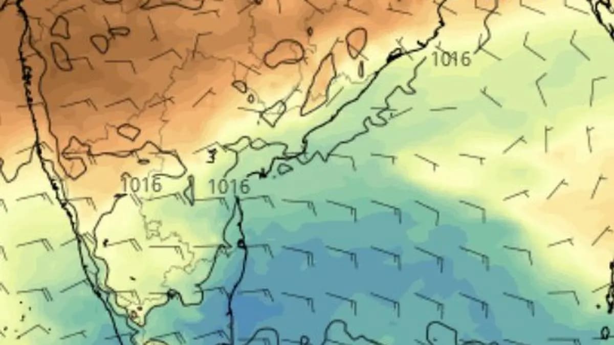
Tamil Nadu and adjoining parts of South Peninsula could look forward to fresh rain (in blue shade) after cyclone Akvan passes the coast to its north. | Photo Credit: www.tropicaltidbits.com
Cyclone Akvan is in no hurry to reach the coast as it crawled north-northwestwards at 3 km/hr over central parts of the south and adjoining west-central Bay of Bengal, a far cry from the double-digit speeds more commonly associated with moving cyclones, while it used the overnight hours to strengthen into a severe cyclone this (Wednesday) morning.
While Akvan has gained strength over the open sea, India Meteorological Department (IMD) has significantly scaled back its forecast of how powerful it will be at landfall by Friday noon. In a major departure from earlier projections, the weather agency now expects it to make landfall as a severe cyclone, as against a very severe cyclone, potentially placing it in the league of its predecessor Arnab.
The downgrade in intensity, however, comes with no let-up in the rainfall and wind warnings for the Andhra Pradesh coast, which remains squarely in the storm’s firing line. The IMD has retained its forecast of heavy to very heavy rainfall at a few places, with isolated extremely heavy falls, over Coastal Andhra Pradesh and Yanam on Thursday and Friday, coinciding with the cyclone’s approach and landfall.
Wind conditions are also expected to deteriorate sharply. Thunder squalls with wind speeds of 60-70 km/hr, gusting to 80 km/hr, are forecast over Coastal Andhra Pradesh and Yanam on Wednesday. These could gather considerable force on Thursday and Friday, reaching 100-110 km/hr, with gusts touching 120 km/hr.
Isolated heavy rainfall is likely over Tamil Nadu, Puducherry and Karaikal on Thursday; Coastal Andhra Pradesh and Yanam on Wednesday and Saturday; and Rayalaseema on Thursday and Friday. Telangana could receive isolated to very heavy rainfall on Friday and Saturday. The cyclone’s inland passage may also trigger rain, thunderstorms, lightning and strong winds over parts of East and Central India.
For Tamil Nadu, however, Akvan could turn out to be something of a near miss in terms of assured rainfall. Located nearly 600 km from Chennai on Wednesday morning, the cyclone appears better positioned to deliver its rain bounty to the Andhra Pradesh coast and adjoining parts of Odisha. Yet the rain story for the South Peninsula may not end with Akvan’s departure. Model forecasts suggest that easterly flows could bring fresh rainfall to the Tamil Nadu coast after the storm passes, potentially aided by an easterly wave drifting across the Bay.
At 5.30 am on Wednesday, Akvan was located about 580 km east of Chennai, the closest reference point among the major coastal locations, viz. 650 km north-east of Trincomalee in Sri Lanka; 610 km south-east of Machilipatnam; 610 km south-southeast of Visakhapatnam; and 730 km south of Gopalpur. It is forecast to cross the coast in the Nellore-Visakhapatnam sector around Friday noon, packing maximum sustained wind speeds of 100-110 km/hr and gusts of up to 120 km/hr.
The scaling down of Akvan’s projected landfall intensity offers another illustration of how a cyclone’s slow movement and prolonged exposure to the surrounding environment can cut both ways. While the extended stay over warm waters initially offered an opportunity to gather strength, the storm is now running into atmospheric and oceanic conditions that are increasingly stacked against further intensification.
The cyclone has entered a zone of increasing vertical wind shear, where wind speed and direction change with altitude. Strong shear can tilt and disrupt the storm’s towering cloud structure, displacing the upper-level circulation from the low-level centre, undermining the organised convection on which a cyclone depends to build muscle. The waters closer to the Andhra Pradesh-Odisha coast are also relatively cooler, at around 28°C, compared with the 29-30°C waters over the deeper Bay where the system originated.
Together, these factors appear to be putting a lid on any further strengthening before landfall. Beyond Akvan, the outlook for the remainder of the Bay of Bengal cyclone season is far from settled. The US Climate Prediction Centre appears, at least for now, to be drawing down the curtains on the prospects of fresh cyclogenesis over the Bay, with its model forecasts showing no potential area of cyclone formation until December 8. Uncertainty over the arrival and influence of passing Madden-Julian Oscillation (MJO) waves appears to be weighing on the outlook.
The European Centre for Medium-Range Weather Forecasts (ECMWF), however, is reading the tea leaves differently. Its projections hint at a possible area of activity over the southern Andaman Sea during the week ending December 7, persisting until December 14, before shifting westwards to a location east of Sri Lanka. Any system that takes shape there would be of considerable interest to neighbouring Tamil Nadu and the wider South Indian Peninsula, particularly as the North-East monsoon season enters its crucial final stretch.
Copyright© 2026, THG PUBLISHING PVT LTD. or its affiliated companies. All rights reserved.
Comments have to be in English, and in full sentences. They cannot be abusive or personal. Please abide by our community guidelines for posting your comments.
We have migrated to a new commenting platform. If you are already a registered user of TheHindu Businessline and logged in, you may continue to engage with our articles. If you do not have an account please register and login to post comments. Users can access their older comments by logging into their accounts on Vuukle.
Terms & conditions | Institutional Subscriber




Loading comments…